
4: December
Variations in precipitation within a region of the country; comparing your school’s precipitation to another Location in the same region
Purpose
Last month students compared their own station data with other stations in their county. In this month’s activity, students compare their own station’s data with another station in their own region (within 100 miles) as they make sense of how geographic location and features (e.g., distance from ocean, elevation, latitude/longitude) can result in differences in precipitation within regions. Students will compare their own meteorologic fall data (meteorologic fall is the full months September, October, and November – see Science Content support below) with the other station’s (in the same region) fall data and explore differences in the locations.

Students will be making a graph to compare their own station’s meteorological fall (September, October, and November) precipitation with another station’s (within their region) monthly rainfall. First, have students use the Station Precipitation Summary data tool to summarize their own station’s monthly precipitation totals for each of the fall months. As a class, decide the components of the graph (e.g., title, axes, labels, scales).
Students start with graphing their own monthly precipitation totals for each month, making sure to leave room for adding a second bar for the other station’s data. 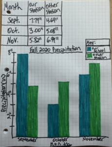 Allow students time to talk with a small group about what they notice about the data.
Choose a station within your region using the CoCoRaHS Active Stations Map and the NOAA US Climate Regions Map. Before sharing the other station’s data with students, discuss where the station is located using the maps. Discuss differences between your own school and the other station such as location, latitude, longitude, and elevation, as well as other geographic features such as a “rain shadow” or proximity to water (see Science Content support for more information).
Ask students to write about what they expect to see from the other station’s data and how it may differ from their own school’s data. Using the Station Precipitation Summary data tool, share the other station’s fall data (monthly totals) and ask students to add these data to their graph. Provide time for students to share what they notice using the data to support their claims. Students will compare how the data align with what they predicted about each station’s precipitation related to geographic location and features.
Standards + Practices
Science
DCI: ESS2.C The Roles of Water in Earth’s Surface Processes
ESS2.D Weather and Climate
CCC: Cause and Effect
SP1: Asking questions and defining problems
Students will be comparing their station’s fall data to that of another station in their region considering geographic features as causal in precipitation variation.
SP4: Analyzing and interpreting data
Students will be analyzing and interpreting Station Summary Reports for their station and another station within their region to consider reasons for variation in precipitation (See Narrative and Science & Math Content Support below).
SP5: Using Mathematics and Computational Thinking
Students will be using mathematical thinking to compare the graphs created using fall data for two stations.
Mathematics
MP1: Make sense of problems and persevere in solving them
MP2: Reason abstractly and quantitatively
MP3: Construct viable arguments and critique the reasoning of others.
MP4: Model with mathematics
MP5: Use appropriate tools strategically
MP6: Attend to Precision
Resources + Supports

Ms. Clark’s Class Investigates Fall Rainfall
Ms. Clark wanted to provide chances for her students to make sense of their data and the data from the other station within their region of the Southeast US, so she posed three questions for them to ask one another: 1) What patterns do I see in the data? 2) What are possible explanations for the data that stand out? and 3) What questions do I have? What data would help me to answer those questions?
When Ms. Clark’s students start digging into the other station’s data; they are surprised by how different their total precipitation for the meteorological fall season (September, October, November) is from the other station’s fall total, which is much less.
")

")
Ms. Clark encourages students to look back in their notes from September through November to see what they had noted about precipitation. Consulting their notes, one student exclaims, “Remember in October? We had a lot of rain right around the middle of the month.” Pointing to their Rainy Days Report data on the CoCoRaHS website, another student chimes in, “That’s right! Look! On October 14, we measured 2.06 inches!” Another student asks, “I wonder what the other station measured that day. Ms. Clark, can we ask them?” Ms. Clark responds, “We have these data because that station has had someone participating in CoCoRaHS just like us, so we can use the site to find out how much precipitation they measured on October 14th.” Ms. Clark demonstrates how to compare the fall total precipitation for two stations using the Station Precipitation Summary data tool. The class fills in the required sections of the Station Precipitation Summary data tool with their station and the other station’s numbers as well as the dates for meteorological fall. Upon reviewing the data, they discover that the other station measured 0.08 inches that day. After looking at the comparison data, one student asks, “Why did we have so much more rain on that day than they did? We aren’t that far away from them!”

At this point, students begin chatting excitedly while continuing to compare the two stations’ data. Ms. Clark divides the class into teams of 3, and assigns each team member a month: September, October, November. Each team member is responsible for taking a closer look at the precipitation data for the two stations that month. The resources that students can use for their investigation include: CoCoRaHS interactive map, CoCoRaHS Station Precipitation Summary, NOAA US Climate Regions Map, earlier weather reports, and news articles about significant weather systems. The team members will then gather to share what they have found with one another.

Meteorological Seasons
Did you know that meteorologists and climatologists look at seasons differently than we do?
Meteorologists and climatologists use yearly temperature data to define seasons, whereas to others, seasons are defined astronomically, or by Earth’s position in relation to the Sun. For the data students will be analyzing during this project, students will view seasons in the same way as meteorologists and climatologists view them in the Northern hemisphere, in three-month cycles, based on temperature data:
- Summer: June, July, and August
- Fall: September, October, and November
- Winter: December, January, and February
- Spring: March, April and May.
For more information regarding this difference, please refer to the following informational page from NOAA: Meteorological vs. Astronomical Seasons
Considering Geographic Features
There may be a large variation in the data students are making sense of due to the different geographic features of the regions. There are two main features that may affect amounts of rainfall and things to consider when making sense of data across different regions:
- Rain Shadow: One side of a mountain has much more rainfall than the other side because the mountain casts a “shadow” on one side sheltering it from prevailing rain-bearing winds and keeping it much drier than the other side. Consider another location in relation to a large mountain range. For more support on this concept, consider the following resources:
- Proximity to water: Winds that blow off of a warm body of water tend to increase humidity and rainfall. Consider another location in relation to a large, warm body of water.
By considering these geographic features, students will be better equipped to analyze, compare, and synthesize the data shared from another location.
Topographic View of Map
On the Main CoCoRaHS.org home page, click on the map in the center of the page.

Next, in the upper right hand corner of the page, click on the three layered squares. Select, “ESRI Topo.”

Zoom in to the location of choice to closely view the topography of the area.

Students can use the Topography view of the map to help discern how geographic location and features can result in differences in precipitation within regions.
Scientists identified nine regions within the continental US with similar climate consistency. This map can be used to determine the climate region your state and school are in for comparing your meteorological fall data with that of another station within your same region.


Rainfall in Autumn
Be sure to clarify that “fall” is referring to the season (i.e., autumn) and not the precipitation, or rainfall, total.

CoCoRaHS Station Precipitation Summary Data Tool
The Station Precipitation Summary tool can be used to compare up to three stations’ precipitation totals for any time period entered. Simply type in the Station Numbers, start and end dates, and click “get summary.” For this activity, type in your station number and the other station in your region you are comparing to, and the dates 09-01-year and 11-30-year to compare meteorological fall data for any given year.

Practice Overview: Analyzing and Interpreting Data
As students compare their fall data with other stations’ data in the same region, there is an opportunity for students to analyze and interpret the data reported at each station.
Analyzing and interpreting data involves organizing and graphing collected data and making sense of it (e.g., finding relationships, patterns, outliers). Various tools can be used in data analysis including spreadsheets, graphing tools, and analytical software. Observation and reasoning help scientists make predictions and form explanations based on the data.
The following video, intended for a teacher audience, provides additional information related to this practice. (0:00-3:50)
How can I help my students organize and graph data?
Attend to the important components of their graph:
- Title: should be relevant to the data and the purpose of the graph (e.g., Fall Precipitation at Two Sites in the Same Region).
- Axis data and labels: independent variables (e.g., date, week, month) should appear on the x-axis and dependent variables (e.g., condition, precipitation amount) should appear on the y-axis. Axis labels should describe what data is being shown on each axis.
- Axis scales: should start at zero and represent equal intervals that span the full range of data.
- Key: necessary to describe how different groups are distinguished on the graph.
Attend to precision when graphing their data:
- Horizontal lines at each y-axis interval helps insure the correct bar height
How can I help my students evaluate and draw conclusions from data?
Compare attributes of two related data sets:
- Describe how the shapes of each data set compare (e.g., data from Station X are more skewed left than the data from Station Y) and what that means in context (e.g., September precipitation at Station X was higher than any other month at either station)
- Calculate the sum and average of each data set and describe what they mean about each data set.

Now that students have compared with another station in the same region, you will be using data from a station in a different region during next month’s activity. You will need to make sure you have that station’s number and are able to access their data on the CoCoRaHS website.